Low Emissions
Command & Control
TITAN BY NORTAC® – Digitizing the Operational Space
TITAN BY NORTAC® provides a secure digital Situational Awareness and Command and Control (SA & C2) capability that operates on commercial satellites, radio and GSM/LTE networks. As a Commercial Off The Shelf (COTS) solution, TITAN BY NORTAC® provides an affordable capability that is ready for deployment.
Designed to augment analogue or digital radio networks, TITAN BY NORTAC® satisfies the C2 & SA, security and encryption requirements of militaries in a cost effective and operationally efficient manner. It facilitates interoperability between the military and civil agencies such as police, border control, first responders, etc. It provides full location, situational awareness and communications capabilities globally, in particular rugged or austere terrain requiring Beyond Line of Sight (BLOS) connectivity. TITAN BY NORTAC ® is simple to train, operate, and deploy, providing customers with a fully scalable solution.
An integratable robust solution offering versatility and scalability. Device and bearer agnostic with M2M capability.
NATIONALISATION
NATIONALISATION
DUAL USE
DUAL USE
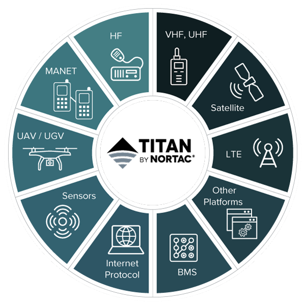
A DIGITAL BUILDING BLOCK
Platform
The platform is the hub of the TITAN BY NORTAC solution. It allows two-way flow between the command centre and remote users. It also allows data laterally between field units connecting remote users to each other. provides organizations with a secure web-based application, or on-premises solutions behind client firewalls. Capabilities include asset and personnel tracking, C2SA, emergency response, and post-operational debriefing.
Mobile Command Posts
Nortac Tactical Awareness Capability (NTAC) is a remote component of the TITAN BY NORTAC® Solution for use at mobile command posts in a field operations center, or in vehicles, boats, or helicopters. Accessed on a tablet, laptop or smartphone it uses low bandwidth satellite, Wi-Fi or LTE networks to provide C2SA in the field anywhere in the world.
Devices
NORTAC® manufactures robust, field tested devices for personnel, aircraft and boats which can be configured according to needs for reporting, messaging, and alerts. Satellite devices, radios, cellphones, video, voice, and other sensors integrate to a common operating picture.
Training and support
NORTAC® provide expert training on every aspect of the Platform and devices.
Integration
The TITAN BY NORTAC® Platform is integrated with other platforms such Esri’s ArcGIS and TAK to allow a live picture of devices in the field to be federated.
The NORTAC Difference
Trusted
More than a decade of providing satellite services and TITAN BY NORTAC® to multiple Canadian Government agencies including military, police, disaster management teams and international customers.
Protected
Customized on-premises server solutions with data isolated behind client firewalls or SaaS hosting on AWS.
Land Air Sea
In remote or urban areas, one platform allows communications and visibility of personnel on foot, in vehicles, aircraft, or boats.
Remote Communications
Capability for remote field users to view an operating picture without relying on cell phone or Wi-Fi networks. This includes access to satellite data, as well as voice and video communications, enabling operations anywhere.
Nationalisation
Countries are increasingly seeking to nationalise and reduce dependence on third parties for critical civil defence systems. NORTAC can offer source code for bespoke TITAN BY NORTAC® solutions to governments and provide the capability for them to undertake further development. TITAN BY NORTAC® provides a first ‘digital building block’ that works and provides immediate capability. The client can adapt and grow it for future needs in a modular fashion using their in-house engineers.
Digital Building Block
TITAN BY NORTAC® acts as the M2M (Machine to Machine) and communications hub for remote devices on various communications bearers. As a digital ‘hub’ it integrates with UAVs, video, sensors, radio, and satellite. Live data feeds can then be provided to other platforms such ESRI’s ArcGIS and TAK.